
Taiwan / Germany
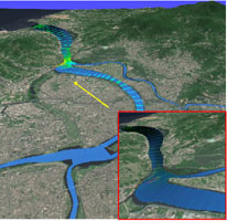 |
A Virtual GIS-Based 3D Hydrodynamic Model of Tamshui River Due to the dense population and rapid economic development of the Tamshui River, the largest estuarine system of the island, Taiwan is studying the river’s hydrodynamic and water quality. Dirty water, air, soil and mudslides pose a threat to public health, causing deaths and property losses during seasons of typhoon and heavy rain. Tele-immersion tools enable researchers to visualize and analyze the computed results. |
| Contact |
Shin-Jye Liang National Center for High-Performance Computing (NCHC) Taiwan c00lsj00@nchc.gov.tw |
| Collaborators |
Shin-Jye Liang, Charlie H. Chang, Kuen-Meau Chen, Alpha Y. Wang, Fang-Pang Lin, Whey-Fone Tsai National Center for High-Performance Computing (NCHC) Taiwan Frank Molkenthin Institut fuer Bauinformatik, Brandenburg University of Technology at Cottbus Germany |
www.bauinf.tu-cottbus.de/taiger
| web @ startap.net |