IUCC
 |
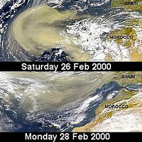
Collection of SeaWiF Data for the Eastern Mediterranean and the Middle East SeaWiFS is a newly developed satellite, integrating advanced technology that acquires multi-channel data over land and sea. Daily SeaWiFS images over the Eastern Mediterranean and the Middle East are received at the J. Blaustein Institute in HRPT format (1.1 km resolution) using a PC-based receiving station. The volume of daily images will range from 30-130 Mb, depending on the area of acquisition. These PCs receive raw HRPT-type data and convert it to level-0 to match the specifications of NASA documentation. Subsequently, each image is transferred from the receiving station to NASA / GSFC, to create a global image based on several HRPT stations across the globe |
| Contact |
Gene Carl Feldman NASA Goddard Space Flight Center USA gene@seawifs.gsfc.nasa.gov Arnon Karnieli J. Blaustein Institute for Desert Research Ben Gurion University Israel karnieli@spamergsfc.nasa.gov |
| Collaborators |
NASA Goddard Space Flight Center USA Ben Gurion University Israel |
seawifs.gsfc.nasa.gov/SEAWIFS.html
| web @ startap.net |